ArcGIS Desktop Professional 19-001
Last Update 4 days ago
Total Questions : 93
ArcGIS Desktop Professional 19-001 is stable now with all latest exam questions are added 4 days ago. Incorporating EADP19-001 practice exam questions into your study plan is more than just a preparation strategy.
By familiarizing yourself with the ArcGIS Desktop Professional 19-001 exam format, identifying knowledge gaps, applying theoretical knowledge in Esri practical scenarios, you are setting yourself up for success. EADP19-001 exam dumps provide a realistic preview, helping you to adapt your preparation strategy accordingly.
EADP19-001 exam questions often include scenarios and problem-solving exercises that mirror real-world challenges. Working through EADP19-001 dumps allows you to practice pacing yourself, ensuring that you can complete all ArcGIS Desktop Professional 19-001 exam questions within the allotted time frame without sacrificing accuracy.
An ArcGlS user receives parcel data from the regional government, which is supposed to line up with parcels in the data maintained by the local government. The user is tasked with reconciling the discrepancies between the local and regional data.
In which situation are the parcel boundaries within the local data more likely to be accurate than the regional data?
An ArcGIS has created a definition query on a parcel feature in a personal geodatabase to only show areas classified as residential. The user's company has decided to update all personal geodatabase to file geodatabases.
When the ArcGIS user updates the source data to point to the parcel feature class in the file geodatabase they receive the following error.
"One or more layers failed to draw:
Parcel: An invalid SQL statement was used. [Select Shape FROM Parcel WHERE [Parcel] B residential]
Parcel: An invalid SQL statement was used"
What is the correct SQL statement for the file geodatabase?
Refer to the exhibit.
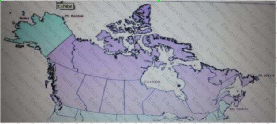
The ArcGIS user is given data for the Arctic, and is asked to perform various types of analysis using the data. The data extends from the North Pole south to 55 degrees North Latitude Data layers may contain points lines, or polygons and include ice surveys from NOAA depth contours; continental margins, locations of known and suspected oil reserves, endangered species habitat and territorial boundaries for nations having Arctic coastline.
An ArcGIS user is asked to calculate the distance a cruise ship will travel through open water, departing from Nome, Alaska, with stops at Point Barrow Alaska Churchill Manitoba St John's Newfoundland and ending in Bar Harbor Maine. On the basis of these calculations the cruise ship line will determine fuel requirements and travel time.
Which map projection yields the most accurate results for this distance calculation?
An ArcGIS user has multiple tables that must be input into a single model. What can the user add to the model to automate the model to run on all tables?
When designing a geometric network where should the feature classes be stored?
An ArcGIS user wants to symbolize the intersections of highways and streets so that the road casing symbols can be blended together to represent connectivity, but not blended in other situations to represent disconnectivity (e.g. where a highway passes under a surface street)
What should be used to ensure that the road casings connect correctly?
An analyst has a multi band raster, but needs just one of the bands for a project. Which geoprocessing tool should be used to extract a single band?
An ArcGIS user requests polygon parcel data to use in a model linking geoprocessing tools. The data the user receives covets the entire country and the large dataset causes the application to perform slowly.
How can the ArcGIS user improve the performance time without altering the model?
An ArcGIS user has a soils polygon shapefile
Which conversion is necessary in order to ensure that the soil polygons do NOT overlap or have gaps?
An ArcGIS user has a project that requires using an image with a spatial accuracy of 5 meters Root Mean Square Error (RMSE) or better.
How should users verify the spatial accuracy of the image?
In the Feature Class to Feature Class tool which parameter allows an ArcGlS user to manipulate attributes to be included the output feature class table?
An ArcGlS user has high-resolution single-band data and another raster datasetthat is multiband with lower resolution. Which process is used to convert the single-band data to multi-band, while retaining its resolution?
Given an elevation surface, a raster of forest stands, and a point feature class of saw mills, which analysis is used to determine the optimal route from each forest stand to the nearest saw mill?


TESTED 05 May 2024
Hi this is Romona Kearns from Holland and I would like to tell you that I passed my exam with the use of exams4sure dumps. I got same questions in my exam that I prepared from your test engine software. I will recommend your site to all my friends for sure.
Our all material is important and it will be handy for you. If you have short time for exam so, we are sure with the use of it you will pass it easily with good marks. If you will not pass so, you could feel free to claim your refund. We will give 100% money back guarantee if our customers will not satisfy with our products.